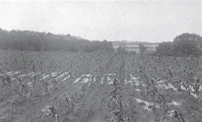
After passing Sheridan about two hundred yards we arrived at
the height of the land westerly from Opequan Creek where the Sixth and
Nineteenth Corps were finally formed in lines of battle running about North and
South behind a narrow belt of timber, except a little in front of the reserve,
facing nearly west toward Winchester about two miles away. The formation of the
ground at this point occupied by the Tenth Vermont and Second Brigade was
unusually peculiar.* The turnpike from this place virtually runs along the
divide westerly towards Winchester between the nameless Creek we came up after
crossing the Opequan and Abraham Creek, now on our right and north and the
latter on our left to the south for a goodly distance the reason for which is
obvious as in all such cases where streams have abrupt banks, while at the
point where we debouched from the gulch we came up and formed line of battle
was another little divide running north and south the east slope of which is
partially an easterly watershed for Opequan Creek, and the west slope for the
ravine or nameless rivulet running south about two hundred and fifty yards in
front of where we first formed line of battle in which was the enemy's infantry
in strong force—probably two divisions or more—in front of our Third Division
but not shown on any map of this battlefield I have ever seen, not even the
official government one used in Haynes’ “History
of the Tenth Vermont Volunteer Infantry.” (See No. 3, 6, 7 and 8
illustrations). It is the ravine through which the little short rivulet runs
shown on said map just in front of our “First position” running southerly into
a tributary of Abraham Creek. I am emphatic in this statement as having
been on the battlefield twice since the fight occurred within a year (1908) for
the purpose of trying to correct false history and maps, I know whereof I
write. I desire to impress this on all historians for I know of no one living
who, owing to my elevated advanced position on the battlefield knows more of
it. These two small divides before mentioned meet each other at right angles
forming a letter T. The pike crosses the horizontal part of the T on leaving
the gulch we came up from the Opequan in, and virtually runs along the first
mentioned divide slightly to the left of all rivulet sources running southerly,
forming the perpendicular part of the T towards Winchester.
_______________
* For nearly a score of years after the Civil War while in
the Sixth U. S. Cavalry, I, as well as all other officers, had to map the wild
country over which we scouted for hostile Indians on the plains between the
Mississippi River and the Rocky Mountains. We used the prismatic compass
bearings and odometer measurements, at the same time sketching the country
passed over, showing all springs, rivulets and streams, their bank formations,
all divides, buttes, mountains, etc., with elaborate notes, and sent the same
to the Engineer Officer of the Department, from which all public maps have
since been made of that country now largely in use. This in a measure had made
me expert in treating such matters as well as battlefields. Never having seen a
map that was correct of the locality about Winchester regarding Sheridan's battlefield
in the first assault on Sept. 19, 1864, or the position of the enemy's
Infantry, artillery, etc., and as so many writers wrongly describe this
assault, I concluded before having my diary typewritten for publication to
visit this part of the battlefield in order to give a fairly correct
description of it; and the one herein is as accurate as can be given without
the use of the prismatic compass, odometer, etc.
SOURCE: Lemuel Abijah Abbott, Personal Recollections
and Civil War Diary, 1864, p. 153-5


No comments:
Post a Comment